Showing posts with label Chicago Riverwalk. Show all posts

Wednesday, July 17, 2013

Giant Punch Stamp on the River? First Renderings for 150 North Riverside office tower and park - Revealed and Considered

click images for larger view
150 North Riverside and date stamp - separated at birth?

Is a new real estate bubble rising around the Chicago River?  Long dormant land in and around Wolf Point is already under construction with two major skyscrapers, and this morning, in an email to his constituents, 42nd Ward Alderman Brendan Reilly unveiled the first renderings I've seen of the proposed office tower for 150 North Riverside, to be built on air rights over tracks leading into Union Station . . .

. . . just east of Graham Anderson, Probst and White's 1922 Butler Brothers warehouse II.
I actually worked for 6 years on its top floor before it was converted by Hartshorne Plunkard into the Randolph Place Lofts.  Unlike its twin building to the south, which was made into - and remains - offices - it's now housing, and the residential nature of Randolph Place may be a key reason while 150 North Riverside is placed in the middle of the site.  The Trib's Blair Kamin is tweeting Goettsch Partners is responsible for the design.
The 1.2 million square foot building is being pushed by long-time John Buck veteran John O'Donnell, now of the Chicago operations of Colliers International.  An April article by Ryan Ori in Crain's Chicago Business reported O'Donnell had given up a request for $20 million in TIF funding to get approval for the project moving forward.  River Point, currently under construction along the river across the street, got $29.5 million in TIF money to cover over the Metra tracks and create a riverfront park.  Instead, O'Donnell wants the city to give him a slice of land worth $4-5 million the city controls to make his site complete.  The rest of it was purchased for $12.5 million in 2011.

According to Crain's, Reilly had been fighting an earlier proposal because the park component wasn't at ground level.  In the rendering released in his email, the park remains entirely at the elevated street level, with no riverbank component
Boeing riverwalk
Across Randolph Street to the south, at the Boeing World Headquarters (originally designed by Perkins+Will in 1990 for Morton Salt), the riverside esplanade is split into two, relatively narrow parts, one above-grade, at the level of Randolph and Lake streets, with another narrow strip descending all the way down to the river. In the 150 Riverside rendering, the plaza space is all at street level, with a larger portion south of Lake tucked beneath the angled cantilevers of the building.
park at River Point
Across the street to the north, on the other side of Lake Street, renderings of the park building built along the river as part of the River Point shows, as at Boeing, a park split between ground and street level.  The ground level links to a riverside esplanade at the River Bend residential tower to the north. The difference is the River Point site is actually set back to the west, parallel to where the Butler Brothers building is sited to the south.  The park itself is to be a built over what looks to be pretty much the whole expanse of the Metra tracks, making the acre-and-a-half park much larger than what's possible at 150 North Riverside.  (Don't be fooled by the rendering, which is drawn from an exaggerated wide-angle perspective that makes the park look only slightly smaller than Yellowstone.)
150 North Riverside
I get what Ald. Reilly is looking for, a continuous riverwalk from River Point to the elevated plaza of the old Daily News Building.  It would require the addition of under-the-bridge linking components, but it would offer up something similar to continuous Riverwalk now under development for the south bank of the river from Lake to Wabash.   The problem, of course, is that it could only go to the old Daily News Building (now Riverside Plaza), at Madison, where the riverwalk south to Jackson is all elevated at street level.  (And let's hope 150 North doesn't give Sam Zell ideas about resurrecting his old plan to build over the Daily News Plaza.  Surprise, surprise, the Commission on Chicago Landmarks has never gotten around to landmarking this essential Chicago building.)
Daily News Building (Riverside Plaza) meets the river
So for continuity, you want a large part of the park at 150 North Riverside to be at an elevated level so it will link it to the existing river walkways north and south.  If you want to split off a walkway along the river, it would have to be somewhat narrow, and, as at Boeing, it's hard to find a graceful way to get people to the lower level without a vertiginous shotgun stairway.  In addition, the 150 North Riverside rendering also shows the space along the river beneath the plaza to be inhabited with some function not clearly apparent.

As for the building itself, if it weren't for the angled cantilever at the bottom, it really doesn't have much to distinguish itself visually at all and, at first glance, I'm not even sure the cantilever works.  There seems to be a lot of tall, tall concrete at the base.  Dear readers, what's your take?

In any event, more should learned from the public hearing.  Welcome to the arena, Mr. O'Donnell.


42nd ward alderman Brendan Reilly is sponsoring a public meeting for his constituents on 150 North Riverside, 6:00 p.m., July 31st in Walnut Ballroom of the Hotel Allegro, 171 West Randolph.
Read More:


Hour of the Wolf:  The Transformation of the Pivot Point of Chicago

The Daily News Building Plaza: Endgame for one of Chicago's Great Public Spaces?

Wednesday, February 20, 2013

Finishing the River Walk - Conclusion: Swimming Holes and Wolf Calls

click images for larger view
When last we left our traversal of the City of Chicago's plans for finishing the Chicago Riverwalk, we were about to cross under the LaSalle Street bridge.  While design for the three blocks to the east is 90% finished, the final three blocks going west are in a much more preliminary stage, with design listed as only 10% complete.
The Swimming Hole, south bank of Chicago River, LaSalle to Wells
The first of these blocks, from LaSalle to Wells, is currently called the Swimming Hole, but according to Chicago Department of Transportation Project Manager Michelle Woods, “I've been strongly encouraged to change the name because the Coast Guard thinks people will grab their beach towel and their flip-flops and go for a swim in the river.”

The Swimming Hole is actually a zero-depth fountain that kids could run through.  “This is the block,” says Woods, “that has the most amount of sunlight throughout the day.  This could be a very fun place for families and enjoy a nice day.  There's all kinds of technology and different things you can do so that the floor could look like a dance floor and light up as the water sprays, as the kids run through.  It could light up and interact with the kids climbing on it.”  The concept includes “more robust” bathroom facilities that would include rooms where kids could change in and out of their swimsuits.
The Jetty, Wells to Franklin
In the current, early concepts, the next block, from Wells to Franklin, is called The Jetty.  “It's actually my favorite block,” says Woods.  “It has fishing piers and floating gardens.  Instead of having a concession here, this would be a place I would like to set up as a classroom space and partner with the Chicago Public Schools and the Chicago Park District to have them bring kids to come learn about ecology, water quality and the history of the river, and maybe give them an opportunity to go fishing and enjoy a natural resource in the middle of the city.  At nighttime, this could be a place where we have caterers, maybe have it leased out for corporate events and nighttime activities.  You could have a glass of wine or a beer and wander around onto the fishing piers and enjoy a nice night on the river.”
The Boardwalk, Franklin to Lake Street
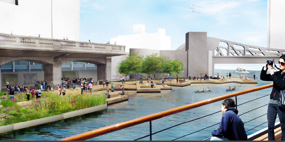
The final block, from Franklin to Lake Street, is called The Boardwalk.  “This is the section,” says Woods, “where we have a 50-foot buildout, and so we have a lot more space.  The idea originally was let's put some floating gardens in, let's have a nice boardwalk area, a nice public space, right at this big confluence of the river at Wolf Point, where people can hang out and enjoy all the traffic and things going on along the river.”  The rendering depicts an “iconic bridge”, that rises from the river level to Lake Street in a gentle slope.  “This is the section,” says Woods, “where I've been challenged - ‘can you create more retail space here?’, can you do something a little bit more ‘Chicago’, so we're working on that now.”
River Point Park
As we wrote previously, this is one segment where we really need to be seeing some kind of co-ordination between the three major park projects around Wolf Point,  In addition to the Riverwalk, $29 million in TIF funds are going to burying the Metra tracks under a new park along the river at the 45-story River Point office tower rising at 444 West Lake,  At the opposite bank, once the billion dollars of development is completed at Wolf Point, 70% of the site will be parkland, with nearly 900 linear feet of Riverwalk.
planned Wolf Point Riverwalk
Everyone doing their own thing is, of course, a grand Chicago tradition, but you can't help but think that it's taken all of Chicago's 175 history to get to the point of reshaping Wolf Point as a public amenity.  Once the pieces are in place, who knows when we'll have this opportunity again.  Doesn't it just make sense to have all the parties sit down and co-ordinate the vistas and functions?

The ultimate objective is to draw 2.8 million people to the Riverwalk each year.  Woods' presentation compared this to Lincoln Park (3 million visitors annually), New York's High Line (3.7 million), and at 5.1 million, the San Antonio River Walk, the gold standard that Ernie Pyle once referred to as ‘The Venice of America’.

The cost of completing the Chicago Riverwalk is estimated at $90-100 million, with over $3 million already spent on the design.  The city is confident that funding will be available from the Federal Transportation Infrastructure Finance and Innovation Act.  Last year, the U.S. Department of Transportation made available $17 billion in loan guarantees through the program's $1.7 billion in credit assistance.

TIFA would finance the Chicago Riverwalk via a 30-year loan at a reduced rate of interest. The loans, often used for things such as toll roads, require a revenue stream to pay them back.  For the Chicago Riverwalk completion, one proposal is to repay TIFA from a TIF,  with Woods mentioning revenue from the Riverwalk concessions as another possibility.  How many concessions and closings for private parties would you need to come up with the over $3 million a year needed to pay back the loan?  And if all the Riverwalk's revenue went to debt service, where would the money come from for regular maintenance?
Those are questions that - at least publicly - have yet to be addressed, but the deal may already be near to closing.  In an interview with Tanya Snyder of the DC.StreetsBlog, outgoing U.S. Transportation Secretary Ray LaHood says that a formal announcement may come as early as next month.  If everything goes well, construction could begin this year, with a completion time of 15 to 18 months per block.

Read: Finishing the Chicago Riverwalk
Part One - Introduction and Block One: The Marina
Part Two - Opera on the River? (or Maybe just some jazz)

Wednesday, February 13, 2013

Finishing the Chicago Riverwalk, Part Two: Opera on the River? (or Maybe just some Jazz).

This picks up from my first Finishing the Riverwalk post last week to continue westward with City of Chicago's new plan to complete the Chicago Riverwalk along the north bank of the river from State Street to Lake Street, which has remained unfinished since the reconstruction of West Wacker Drive over a decade ago.
CDOT Chicago Riverwalk proposal - The Cove (click images for larger view)
In my previous post, I started with the Marina, from State to Dearborn.  Today, we're moving on the The Cove, in the next block, Dearborn to Clark. “This is much more of a family oriented location,” says Chicago Department of Transportation Manager Michelle Woods, who presented the proposals at a public meeting at the Chicago Architecture Foundation last week that also included architect Carol Ross Barney and Sasaki Associates Principal Gina Ford.  “Instead of formal steps going down, this gently slopes down and is like a sand dune kind of experience.  We have native grasses and things that could withstand being flooded and submerged in our 100-year rainstorm.    This could be another great place for people to come and hang out out of the traffic of the main branch of the river.  Maybe we have a kayak concession renting out vessels.  We might have something where people could come and just rent out chairs and sit and have lunch, watching all the activity taking place as the river is floating past them.”
CDOT Chicago Riverwalk proposal - River Theater, Clark to Lasalle
The next block, the River Theater, from Clark to LaSalle, is the one specifically designed to bring together a large number of people either informally or as the audience for programs. “I like to call it Michelle's Woods, ” joked Michelle Woods, “because I'm so humble.  So this is kind of Chicago's Spanish Steps, if you will.  We'll have this great big grand stairwell that comes down to the river, and then gently cutting throughout the stairways is a nice ramp so if you have a wheelchair, or if you have a child in the stroller, you'll be able to come from up to down.  This is a location where we would potentially have the water taxi service or maybe a dinner boat cruise..”

“For those of you who are into landscape architecture, I really like to point out the great job the team did on the tree pits and the tree gates.  This is the first of its kind tree gate - instead of having a typical boxed pit, we're doing trenches, mostly, so it's going to help with the sustainability of the trees over the long term.  You can also see they've cut into the steps for the tree grates to help with the life of the tree.”

It's here where you could imagine audiences gathering for formal programming, and then you have to figure out where you put the performers.  One thing that's missing from the formal CDOT presentations is context.  There are a lot of renderings of what the new installations would look like, and few showing what they're actually looking at on the other side of the river.  In the case of the River Theater, the direct backdrop is the the 1914 Reid Murdoch Building, with its distinctive clock tower.
At the Reid Murdoch, the upper level promenade is catwalk-shallow, but there's also a lower level plaza, which has had tables for the Fulton on the River restaurant, which could serve as a stage for the Theater on the other side of the River.  Or maybe you put performers on a floating barge stage. 
Or maybe one, last Neiman Marcus sized idea . . .
set for Giordano's Andrea Chénier © Bregenz Festival -photograph: Kristi Sauer
This is a photograph of a production of Giordano's opera Andrea Chénier at the Bregenz Festival, in Austria.   Every two years a stage like this is built above a concrete core in Lake Constance.  The spectacular water bourne sets, of which you can see more here, must be of lightweight construction and capable of being disposed of in an economically sensitive way.  Me, I'm holding out for a Chicago riverfront production of Turandot, with Lisa Madigan as Turandot, Mike Madigan as Altoum, Richard Daley as Timur, Rahm as Calaf, Toni Preckwinkle as Liu, and Ed Burke, Jean-Claude Brizzard and Pat O'Connor as Ping, Pang and Pong.  Costumes by Nick Cave; sets by Jeanne Gang, direction by David Cromer, the Grant Park Symphony and Christopher Bell's Chorus conducted by Carlos Kalmar . . .

Oh, sorry, got a bit carried away for a moment there.  I can just picture the very idea of a floating barge large enough to support an opera sending the Army Corp of Engineers into convulsions, but entertainment on a saner scale isn't only possible; it's already being done.

Last year, or maybe the year before, I was coming home, walking along the north branch by the ABA Tower, when I heard jazz music wafting up in the night air.  Lagniappe, one of the seasonal cafes set up in what under the new proposals is  to be The Cove on the south bank, had blues and jazz nights throughout the summer, and as I listened, I shared the music with an impromptu flotilla of boats hovering on the river around the cafe.  With the music playing out in a soft acoustic like a velvet glove, the traffic moving along Wacker, and the lights of the skyscrapers reflected in the windshields of the boats as they bobbed on the water, it was if the entire river had become a hypnotic music video.
I think the River Theater is a great concept.  Mayor Emanuel apparently thinks so, too, at least according to CDOT Commissioner Gabe Klein, who was at the back of the room for Michelle Woods' presentation last week. “The Mayor and I  both love this one the best,” said Klein, “although I shouldn't speak for him.  For me, I like that it breaks down the barrier between Wacker Drive and the River . . . Right now, there's such a barrier and the contiguous bit is so crucial to the project.  I think the Mayor also likes this because he actually seems the potential for some small performance-type space as well.”  Ballet, we could do ballet, too.  (Actually, the two level promenade and the windows and tower of the Reid Murdoch could make a great setting for choreographers to move their dancers through their patterns.)

The River Theater is the last block in the new Riverwalk proposals where CDOT says the design work is 90% done.  For the balance of the blocks, going to Lake Street, the design work is said to be only 10%, but there are already some ideas, and we'll cover them in our last post of River Walk proposals next week.

Wednesday, February 6, 2013

Shall We Gather at the (Chicago) River?

The Cove, south bank, Dearborn to Clark (click images for larger view)
Tonight, Wednesday February 6th, the Chicago Department of Transportation is holding a public meeting to formally present plans for the completion of the Chicago Riverwalk.  The session will be at the Chicago Architecture Foundation, 224 South Michigan, from 5:30 to 7:00 p.m.
A funny thing happened when they rebuilt the east-west segment of Wacker Drive, the double-wide, double-deck roadway that runs along the south bank of the Chicago River.  For cars, it was finished completely in 2002.  For people, well, the attitude was that they'd get to it eventually.  No one had bothered to get the money for finishing the lower riverfront promenade, and it's remained in a raw, abject state ever since, mitigated only by a series of rudimentary summertime cafes.
Things began to look up a bit with the 2005 completion of Carol Ross Barney's Chicago Vietnam Veterans Memorial.  In 2009, Ross Barney carried the riverwalk forward to State Street, with a striking reflective panel under Wabash that captures the waves of the river . . .
. . .  and a new one block segment to State where the actual riverwalk was shunted to the periphery, in favor of a massive outdoor patio for a restaurant that, entirely coincidentally, was best known for running full page newspaper ads with pictures of local politicians . . .
In 2009, Skidmore Owings and Merrill issued a comprehensive Chicago Riverwalk Main Branch Framework Plan, which provided co-ordinated analysis and proposals for the entire stretch of the river from Wolf Point to the Lake.  It's scope was sweeping, from completion of DuSable Park to the East, to a public market under upper Wacker, to a “Confluence District” along all banks around the split of the river into north and south branches at Wolf Point.

Last October, Chicago Mayor Rahm Emanuel announced plans for the completion of the Riverwalk -   “our second shoreline” - the final six blocks from State Street to Lake Street.   Partners in the project are Ross Barney Architects, Sasaki Associates, Alfred Benesch and Company, and Jacobs/Ryan Associates.
The new plan works hard to balance formal and informal, with a wide range of concepts and functionality.  Each block has its own concept: The Marina (from State to Dearborn); The Cove (Dearborn to Clark); The River Theater (Clark to LaSalle); The Swimming Hole (LaSalle to Wells); The Jetty (Wells to Franklin) and The Boardwalk (Franklin to Lake).  Anticipated functions include kayak rentals, docking space, fishing, fountains, gardens, and educational installations on the ecology of the river.  (If it's finished in time for President Obama to come by for the dedication, maybe they'll even be skeet shooting.)
Franklin to Lake segment of riverwalk, current condition
The Boardwalk, Franklin to Lake segment, new plan
The Confluence, Franklin to Lake segment, 2009 SOM plan
As far as the public disclosure is concerned, the new proposals appear to exist primarily as a series of pretty pictures.  If detail and specifics on the order of the SOM plan exist anywhere on the internet, I've yet to find it.  Where is the night lighting in the renderings?  Where are the back-office operations - storage, public restrooms, etc?  I've already mentioned how the O'Briens cafe overwhelms its segment of the riverwalk from State to Wabash, but in the final six blocks, food service appears to end in the easternmost segment, and even there it's all but invisible in the rendering.
The Marina, State to Dearborn segment, new plan
Where SOM had their Confluence District, the new plan seems to be everyone for themselves. If there's any co-ordination between what the city wants to do along the south bank, and how it will relate, visually or functionally, to what Hines Interests is planning for the TIF-funded park at their new River Point office tower at 444 West Lake, or what the Kennedy Interests is planning for their mega-development at Wolf Point, I've yet to find any reference to it.
The Jetty, Wells to Franklin segment, new plan
At the time of the Mayor's announcement last October, there was no funding in place for the project's estimated $90-100 million cost.  According to the press release, Emanuel “has charged CDOT to find creative ways to finance the construction of the remaining six blocks from State to Lake .”  It looks like the U.S. Department of Transportation is the most likely mark from which to shake the loose change.
The River Theater, Clark to LaSalle segment, new plan
So many hopes.  So few details.  Maybe tonight.  Again, it's a public meeting, so you can check it out for yourself, 5:30 to 7:00, at the Chicago Architecture Foundation, 224 South Michigan.
The Swimming Hole, LaSalle to Wells segment, new plan